
Invasive Species & Wildfire Risk
By Tori Yanco
On the morning of August 8th, 2023, a downed powerline sparked a small fire near the Hawaiian town of Lahainai. Firefighters quickly dampened the initial blaze, but failed to fully extinguish it, and as winds gusting to 67 miles per hour picked up throughout the day, the fire roared back to full strength, burning through the town and to the shore of the Pacific Ocean in just 2 hours (NASA, Balch et al. 2024). The Lahaina fire destroyed nearly 2,200 structures, created at least $5.5 billion in economic losses, and caused over 100 casualties, making it the deadliest US wildfire in the last century (US Fire Administration; NPR).
Strong winds drove the fire, making its path harder for local fire authorities to predict and manage. But dense, dried vegetation surrounding Lahaina created a tinderbox of fuel that effectively acted like gasoline, enabling the fire to explode out of control. Lahaina is surrounded by abandoned sugarcane plantations that have been overrun by a thick blanket of invasive grasses that create extra fuel for wildfires (County of Maui). These grasses, which in Lahainai include buffelgrass and guinea grass, now cover up to 25% of land area on the Hawaiian islands and carry up to 8 to 20 tons of combustible fuel per acre (USDA; WSJ). Unlike the native vegetation they displace, these invasive grasses create standing dead biomass year-round, so fire risk is perpetually elevated (Ellsworth et al., 2014). Left unmanaged, these invasive plants form dense continuous fuel beds that connect explosively combustible landscapes directly to communities.
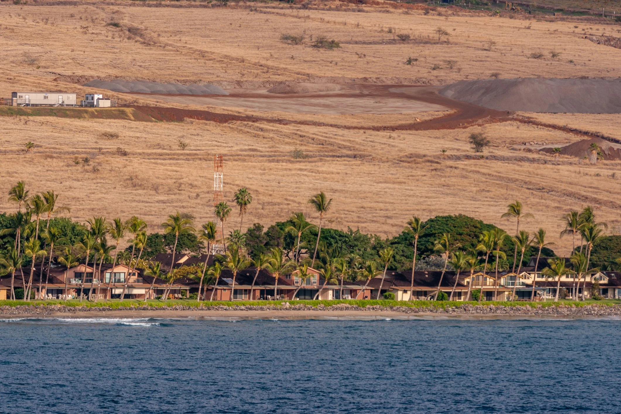
Lahaina, Maui, Hawaii
Invasive Species and Wildfire in the US
While the Lahaina fire is a prime case study of the destructive influence of invasive vegetation during wildfires, it is hardly a rare story. Enabled by landscape disturbance, such as agricultural activity and development, introduced non-native species outcompete native vegetation. For decades, scientists have documented how invasive plants - including trees, grasses, forbs (herbs), and shrubs - are altering wildfire regimes, or the typical pattern of fire in a specific region across an extended period of time (D’Antonio & Vitousek, 1992; Fusco et al. 2019). While all of these plants can influence fire regimes, the invasion-fire interactions of alien grasses are the most extensively quantified in the research literature (Lima et al., 2026). A 2019 study found that 8 species of invasive grasses have increased fire occurrence by up to 230% and fire frequency by up to 150% across 29 US ecoregions, accounting for one third of the contiguous United States (Fusco et al. 2019). Invasive species like cheatgrass (Bromus tectorum) and medusahead (Taeniatherum caput-medusae) are a major component of the increased frequency of fires in the Great Basin, now dominating nearly one-fifth of the region’s 200,000 square miles (Davies et al. 2023; Smith et al. 2021). In Eastern Oregon, Ventenata dubia is transforming the previously fire resistant rocky scablands into fire-promoting corridors - increasing fuel loads by 50 times that of uninvaded areas (Cornwall, 2022). In Southern California, hillsides are carpeted in a blanket of yellow flowers in spring. While many view the golden hue as a characteristically Californian spring time bloom, the hillside’s color comes from the invasive forb, Black Mustard (Brassica nigra), which grows in dense monocultures that dry out to create dangerously combustible landscapes by late summer (CAL-IPC; UC Davis). Even regions that don’t typically make headlines for large wildfires are seeing increased fire activity propelled by invasive species. Southeastern forests are vulnerable to degradation due to changes in fire activity caused by drought conditions and the expansion of invasives like Cogon grass (Cornwall, 2022). In several regions of the US - from southeastern pine savannas to Pacific Northwest forests to the Hawaiian Islands - invasives have been shown to alter wildfire regimes, in many instances increasing the risk of destructive fires for nearby communities (Zouhar et al. 2008; Brooks et al. 2004; Ellsworth et al., 2014; Fusco et al. 2019; Cornwall, 2022).
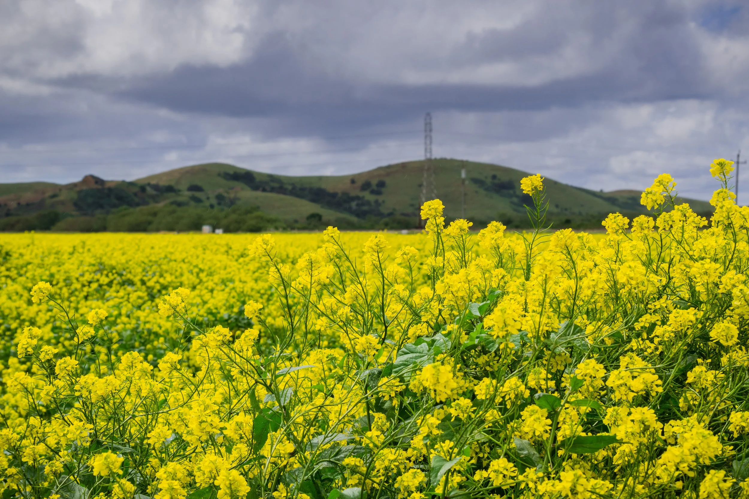
Invasive black mustard field, Coyote Hills Regional Park.
What We Know About the Grass-Fire Cycle
There are several reasons invasive grasses increase fire risk. Introduced grasses can outcompete native vegetation and, once established, often form dense monocultures - replacing patchy shrub and woodland fuels with a continuous carpet of fine fuels. These are what fire managers call “flashy” fuels, as they dry out earlier than natives, ignite more easily, and carry fire across gaps that would otherwise slow or stop it (Colorado State Forest Service; NAISMA). Because grass invasions make the landscape more prone to fire by altering fuel characteristics, fire can occur more frequently than native plants can tolerate, making it easier for the invasive grass to gain dominance. This can create a vicious cycle in which each fire makes the next more likely by encouraging further invasive grass establishment - a self reinforcing feedback known as the grass-fire cycle (D’Antonio & Vitousek, 1992; Brooks et al. 2004; Kerns et al., 2020). Over time, that feedback can convert shrubland and woodland to grassland and drive losses in biodiversity (Miniat et al. 2021). The result is an altered fire regime: invaded landscapes ignite more readily and burn more frequently. Across the Great Basin, cheatgrass-dominated land had a fire return interval of roughly 78 years, less than half that of the native sagebrush it replaces, and cheatgrass made up 24% of the area burned in the region's fifty largest fires despite covering only 6% of the landscape (Balch et al., 2013).
The dangers of landscape conversion and fine fuel accumulation are visible where the majority of wildfire losses actually occur. Between 1990 and 2020 more land in the contiguous United States was burned by grassland fires than forest fires, and 64% of US homes destroyed by wildfire were burned by grassland fires (Radeloff et al., 2023). While these figures describe grassland fire generally, not invaded landscapes specifically, they establish what is at stake as invasive species continue to proliferate across ecosystems. They also raise an important question no one has yet answered: what share of those losses is attributable to invasive vegetation?
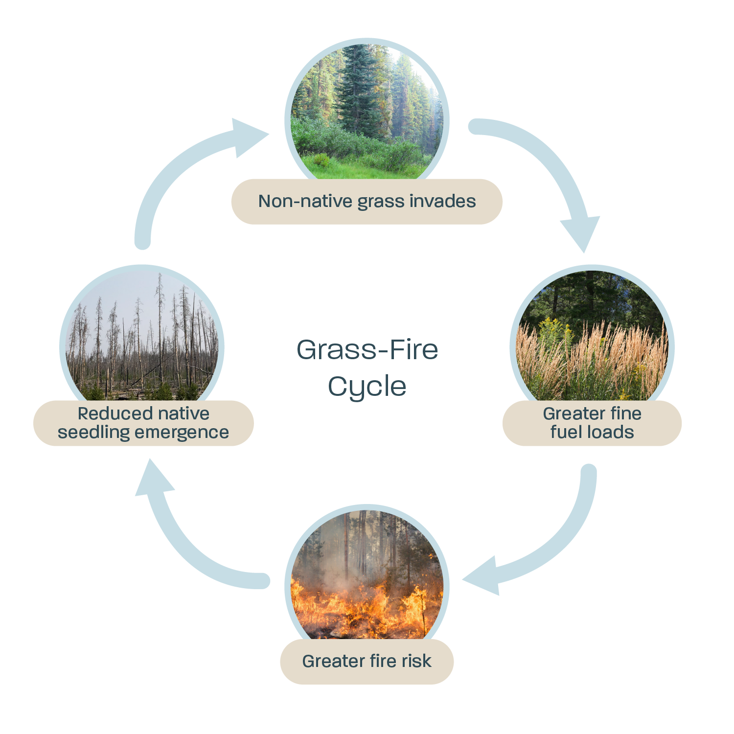
The grass-fire cycle. Adapted From: British Ecological Society Journals (Tomat-Kelly et al., 2021)
Wildfire Models Can't See Invasion
Part of the reason why that question remains unanswered is that the tools we use to estimate wildfire risks were not built to detect invasion or explicitly represent it. Wildfire is modeled as a function of ignition (e.g., campfires, lightning, powerlines), climate & topographical variables (such as wind, temperature, soil moisture, and slope), and fuel (vegetation and buildings). Fuel plays a critical role in determining how easily fires ignite, how quickly they spread, and how intensely they burn. It is also the only input fire managers can act on, and the one invasion changes. But fuel is not simply a measure of how much vegetation exists on a landscape. Fire behavior depends on fuel characteristics including fuel size (twigs versus large trees), fuel load (the amount of combustible material), fuel continuity (whether fuels form connected pathways for fire spread), fuel moisture, and fuel curing (how quickly vegetation dries into flammable material) (OSU; Pyne et al. 1996). Invasive species alter several of these components at once. For example, they can increase fuel continuity by filling gaps horizontally and vertically, and they cure earlier than native vegetation - shifting flammable conditions earlier in the season and extending the window in which fire can spread.
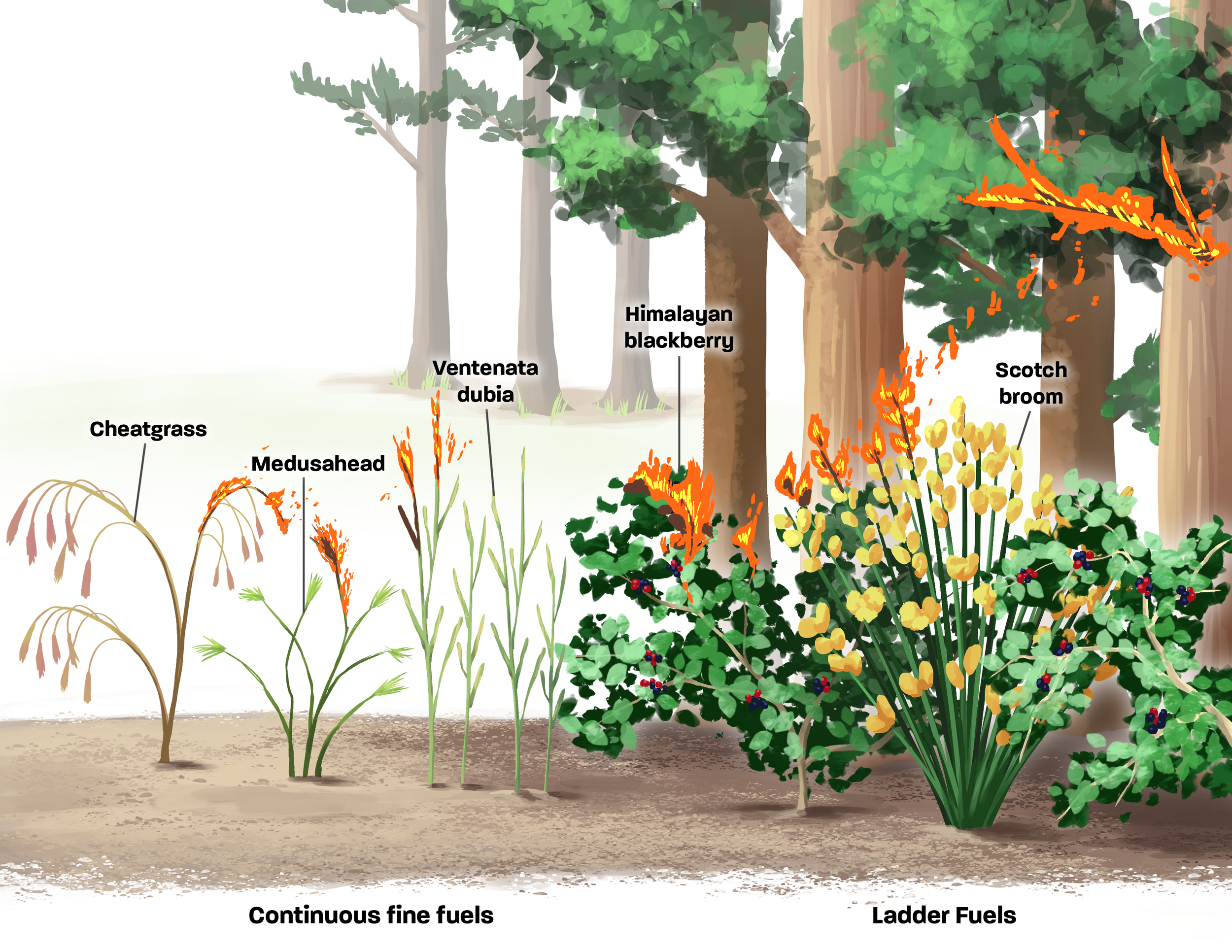
Continuous fuels (horizontal arrangement) vs ladder fuels (vertical arrangement). Adapted from: Oregon State University
Fuel is incorporated into most operational wildfire models through categorical vegetation and landscape classifications that represent fire behavior characteristics. Widely used national fuel datasets, such as LANDFIRE, use satellite imagery together with field observations and environmental data to estimate vegetation and fuel characteristics at a 30-meter resolution (USGS;La Puma, I.P, 2023). There is no fuel model specific to invasive shrubs - only to shrubs as a general structural class - so invasion becomes visible to the model only when it shifts a pixel's mapped vegetation class altogether. LANDFIRE does offer seasonal adjustments to account for invasive species, but this accommodation is narrow: of the many nonnative grasses known to alter fire behavior across the US, only two - Bromus tectorum L. (cheatgrass) and Cenchrus ciliaris L. (buffelgrass) - currently have dedicated adjustments (La Puma, I.P, 2023) .
Because these products infer fuel conditions from remotely sensed vegetation, field observations, and periodic updates rather than explicitly mapping species-level extent, gradual changes in invasive vegetation can alter fuel properties before they are reflected in operational fuel maps. Landscapes undergoing invasive plant expansion may continue to receive the same fuel classification even as fuel continuity, curing, and other characteristics important to fire behavior change. These shifts can be especially difficult to detect when invasive grasses grow beneath shrub or forest canopies, where overstory vegetation masks changes in fine fuels. Satellite imagery often fails to capture early stages of invasion, when non-native species are dispersed among native vegetation and do not substantially alter the landscape’s detectable signal. By the time invasions become widespread enough to identify remotely, they may have already altered fuel conditions and wildfire risk.
Even where invasion is mapped correctly, the classification may not capture the difference that matters. An invasive annual grass replacing a native perennial grass means the landscape can still be accurately classified as grassland, while shifting the timing of curing weeks earlier and extending the season in which the fuel bed will carry fire.
Emerging technologies such as LiDAR can improve estimates of understory fuel structure beneath canopy cover, but they generally cannot identify the species driving those changes or their associated fire behavior characteristics. These limitations create a disconnect between modeled fuel conditions and the actual conditions influencing fire behavior on the ground.
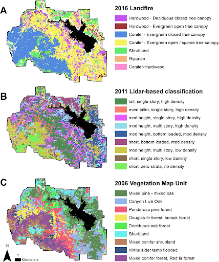
Example of vegetation classifications used for wildfire modeling. Figure 1 from Beckmann, et al. 2025.
You Can't Manage What You Can't Measure
This measurement gap not only affects wildfire modeling efforts, but has downstream effects of how fuels actually get managed. As the old adage states - you can’t manage what you can’t measure. Wildfire management has historically relied on metrics that are relatively straightforward to quantify: acres treated and tons of fuel removed. These metrics allow agencies to track progress, allocate resources, and evaluate whether management actions have reduced hazardous fuels before the next fire season. However, invasive species do not fit neatly into these existing frameworks, as acres treated is a proxy for risk reduction only when treatment reliably reduces hazard. In some invaded ecosystems, fire treatments can have unintended consequences by creating conditions that favor invasive grass establishment and a subsequent increase in future fire risk (Kerns et al. 2020). It is far more difficult to quantify whether an intervention reduced invasion-driven wildfire risk by a measurable amount, because doing so requires knowing where invasives are present, how they altered fuel conditions, whether treatment prevented future spread, and whether the ecosystem shifted toward a less fire-prone state.
This challenge has also been reinforced by institutional separation. Invasive species management and wildfire management have historically developed as separate fields, with different agencies, funding mechanisms, and research communities. While both influence the same landscapes, they have often pursued different objectives: preventing ecological degradation on one hand and reducing hazardous fuels and protecting communities on the other. In regions such as the Great Basin, invasive species management has long occurred through ecological restoration and land health programs, but these efforts have not always been integrated with wildfire risk reduction strategies. Recent efforts reflect a growing recognition that invasive species and wildfire risk are interconnected. In 2022, the National Invasive Species Council and the Wildland Fire Leadership Council released a joint framework calling for greater coordination between invasive species and wildland fire management, including improved data, research, and decision-support tools. At the state level, California has begun incorporating invasive vegetation into wildfire resilience goals with the CA Wildfire and Forest Resilience Task Force’s 2026-2031 Draft Landscape Resilience Action Plan, which proposes a goal to reduce the proportion of shrubland with excessive (>50%) invasive grass cover. While a positive shift, these efforts remain an early step toward integrating invasive-driven fuel changes into wildfire management frameworks.
Wildfires will continue to increase in severity as climate change drives hotter and drier conditions, extreme wind events intensify fire behavior, development expands into the wildland-urban interface (WUI), and landscapes continue to change through invasion-driven dynamics. Together, these interacting drivers are reshaping where wildfire risk occurs, in some cases increasing hazard in areas that historically experienced lower fire risk. While climate, weather, and expanding development receive considerable attention in wildfire planning, invasive species represent another important piece of this broader landscape change but have yet to receive the same level of management attention, in part due to many of the limitations discussed.
Many of the drivers of wildfire risk, specifically those influenced by climate change, are difficult to control at the local scale. Fuel conditions, however, represent one component of wildfire risk where targeted management can reduce exposure and improve landscape resilience. Fuel management remains challenging due to political, legal, social, and regulatory barriers, such as land ownership, liability risk, permitting requirements, and community concerns tied to specific treatment methods, such as smoke exposure from prescribed burns or herbicide drift and water contamination from chemical treatment. Overcoming these barriers requires a clearer understanding of the benefits of targeted invasive species fuel management: How much do invasive-driven changes in fuel conditions contribute to wildfire losses? Where can targeted interventions most effectively reduce risk? What are the economic benefits of investing in prevention before landscapes transition into more fire-prone states?
To move from recognizing invasive species as a wildfire concern to effectively managing their impacts, decision-makers need tools that connect invasive-driven changes in fuel conditions to changes in fire behavior, hazard, and expected losses. This requires integrating ecological information about invasive species with wildfire simulation and risk assessment frameworks, while also strengthening coordination between invasive species and wildfire management programs. By quantifying how invasive-driven fuel changes influence wildfire risk and economic losses, policymakers, insurers, and communities can better prioritize investments in landscape-scale interventions where they will have the greatest impact, and least risk for unintended consequences. Integrating invasive species management into wildfire planning and fuel management policies will be essential for managing the increasingly complex drivers of wildfire risk and building long term landscape resilience in a changing climate.
