
Developing Pathways to Better Account for Nature’s Benefits in the National Flood Insurance Program
By Renee Collini and Allison DeJong (Community Resilience Center at The Water Institute)
The vast majority of insurance policies that cover flooding in the US are written by the federal National Flood Insurance Program (NFIP), which provides flood insurance to participating communities that proactively manage their floodplains. Many communities in the US are experiencing increased flood risk, including those that have never flooded before. As a result, these communities are increasingly looking to invest in projects that could reduce flood risk, including nature-based solutions, or natural and nature-based features (NNBFs). However, the NFIP’s pricing system, known as Risk Rating 2.0, is not set up to incorporate the risk reduction benefits of NNBFs or other smaller projects that are effective at reducing flood risk and flood damages. This is a key challenge at a time when many coastal residents are facing high costs for their NFIP policies even if the community has invested in nature-based risk reduction.
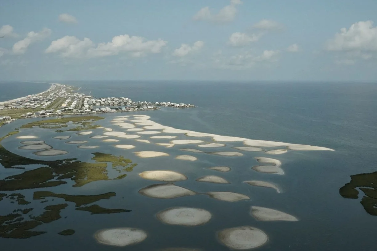
Photo of restored marsh (pre-planting) in Graveline Bay, Dauphin Island, Alabama. Photo by Sam St. John of Fly the Coast.
Pilot Project: Reflecting Nature in Flood Insurance
At the Community Resilience Center at The Water Institute, we recently completed a pilot project that explored this connection between NNBFs and insurance pricing. A marsh restoration project in Graveline Bay, on Dauphin Island, Alabama, added over 60 acres of marsh to the area in 2023. The project’s goal was to restore habitat, but it seemed clear that this project would have an added benefit of reducing flood risk for adjacent homes by buffering coastal storm surge.
When we asked FEMA officials how to connect reduced flood risk from local restoration projects to nearby residents’ NFIP flood insurance policies, they advised that property owners should reach out to their insurance agent, and then FEMA would reevaluate the risk. Our pilot tested this approach by partnering with Moffatt & Nichol, who designed and engineered the marsh restoration project, and Munich Re US, who supports both the private flood insurance market and the NFIP Reinsurance Program.
Our partners found through their engineering analysis that the marsh is effective at lowering risk by reducing wave heights and water levels during minor flooding, such as high tides, as well as major flooding, like tropical events. They also found that the reduction in wave heights and water levels reduced average annual losses (AAL) for the adjacent properties by between 9% and 18%. While AAL is not the only factor in determining the price of a flood insurance policy, it is a meaningful component of the premium. Because these properties are now less risky to insure, we were hopeful residents could expect a decrease in the premium.
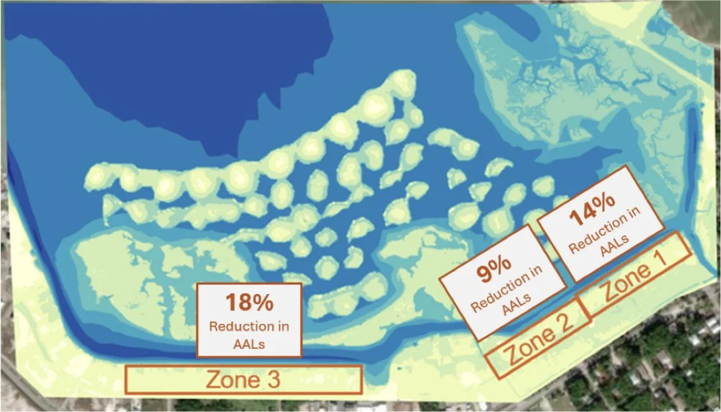
We communicated these results to the residents living next to the marsh. The residents were glad to know that the marsh was reducing their flood risk. However, the residents and their insurance agents were not able to communicate the misaligned risk with FEMA or the NFIP. They also were not able to use any kind of formal process for adjusting mapping that had existed under previous NFIP systems prior to Risk Rating 2.0 when maps were connected to ratemaking.
Promising Pathways for Integrating Nature into Insurance
While the Graveline Bay pilot was underway, we were also invited to participate in a project led by the Environmental Defense Fund (EDF) exploring similar questions at a national level. The ultimate output of the EDF project was the report Recommendations to Better Integrate Nature-Based Solutions into the Models and Pricing Used by the National Flood Insurance Program. The EDF report and the Graveline Bay pilot study both identified some key opportunities for integration of nature into flood insurance.
One potential pathway is incorporating updated geophysical data, such as elevation or topography, from new nature-based infrastructure investments into the catastrophe models that are used to assess risk for the NFIP and inform pricing. However, the update cycle for these models can be several years, there is no standardized process to provide very localized data to the models, and the assemblage of models used would require updating multiple independent models.
Another avenue is the potential for a post-model adjustment for NNBFs. A post-model adjustment is applied to the premium determined from catastrophe models, and it may be more practical to implement than adjusting the underlying input data. Similar to how the existing NFIP pricing system approaches levees by validating and adjusting for levees after the modeling work is done, this pathway could potentially offer a similar adjustment for projects adding new NNBFs to a landscape, like the marsh restoration in Graveline Bay.
Another possible approach is leveraging and enhancing the Community Rating System (CRS), which is part of the NFIP. The CRS rewards participating communities with premium reductions when they undertake certain qualifying flood risk management activities. The existing CRS program, however, can be administratively burdensome, especially for smaller and less resourced communities, limiting participation. Additionally, CRS is currently revenue-neutral at a state level, meaning that if one community’s CRS score improves, the earned discounts are offset by increasing the premiums of other communities in the state. This structure amplifies disparities between communities in the same state. While the risk reduction benefits of nature could potentially be credited to a community through CRS discounts, this does not offer a pathway to adjusting the underlying risk assessment, and many communities would not be able to participate. CRS reforms outlined in EDF’s report may be able to support better integration and improve this option as a pathway.
Moving Forward
Many studies have highlighted the benefits of NNBFs at reducing wave energy and flood risk. This pilot moved beyond assessing the physical risk and connected it specifically to a reduction in financial risk for insurance and reinsurance companies. An essential component of this was that the reinsurance companies that would take on the financial risk used their own assessment methods to determine how much less risky these properties are to insure.
Moving forward we are continuing to work across the insurance landscape to share this information and explore pathways for integrating risk reduction measures into pricing. We are also working to conduct more pilots to build out our understanding of how different NNBFs reduce risk to further support a more systematic approach to integrating risk reduction into pricing and availability.
Insurance is an essential part of resilience, and as costs increase more people are unable to have access to an important tool in mitigating the impacts of risks. Advancing this work supports affordable and available insurance while also fostering investment in a broader range of risk reduction techniques.
For more information on these opportunities, please read the Water Institute’s briefing document on the Graveline Bay pilot, available here.
For more information on the EDF report, read here.